Spotting Natural Catchment Areas for Gold in Water-Scarce Regions
Spotting Natural Catchment Areas for Gold in Water-Scarce Regions
Gold prospecting is often challenging, especially in water-scarce regions where traditional methods of exploration may be impractical. But, identifying natural catchment areas can significantly enhance the likelihood of discovering gold deposits. This article explores the strategies for spotting these catchment areas, the underlying geological principles, and the potential benefits of targeted exploration.
Understanding Natural Catchment Areas
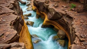
A natural catchment area, or watershed, refers to the land where precipitation collects and drains into a common outlet. In the context of gold prospecting, these areas can serve as vital indicators of potential gold deposits. Geologically, gold is often eroded from primary sources, such as quartz veins, and transported by water. When water collects in these catchment areas, it can concentrate gold particles in alluvial deposits.
Geological Indicators of Gold Deposits
When assessing a natural catchment area for gold, several geological indicators should be considered:
- Bedrock Type: Regions with igneous and metamorphic rocks, such as granite and schist, are often associated with gold mineralization.
- Soil Composition: The presence of fine-grained soil, especially in low-lying areas, may indicate the accumulation of eroded materials.
- Stream Patterns: Analyzing the patterns of local streams can reveal areas where gold is likely to accumulate.
Techniques for Identifying Catchment Areas
Several techniques can be employed to pinpoint effective natural catchment areas:
- Topographic Maps: Utilizing detailed topographic maps can help identify elevations and depressions that influence water flow and accumulation.
- Remote Sensing: Satellite imagery and aerial photography can reveal vegetation patterns and water bodies that indicate catchment areas.
- Field Surveys: Conducting ground surveys to collect soil samples can provide data on mineral content and particle distribution.
Real-World Applications: Case Studies
Various case studies illustrate the efficacy of exploring natural catchment areas for gold. For example, in Nevada’s Carlin Trend, significant gold deposits have been identified in areas where erosion has transported gold from bedrock to nearby catchments. Similarly, in South Africas Witwatersrand basin, research has shown that gold is often located in sedimentary deposits formed in ancient riverbeds, demonstrating the importance of ancient catchment dynamics.
Challenges and Considerations
While exploring natural catchment areas shows promise, several challenges may arise:
- Water Availability: In water-scarce regions, the lack of visible water sources may hinder prospecting efforts.
- Environmental Impact: Gold prospecting can have ecological consequences, necessitating sustainable practices.
- Legal and Regulatory Concerns: Adhering to local regulations regarding exploration is crucial to avoid legal issues.
Actionable Takeaways
Spotting natural catchment areas for gold in water-scarce regions requires a strategic approach that combines geological knowledge and advanced exploration techniques. Here are key takeaways for aspiring prospectors:
- Study the geology of the area to understand potential mineralization.
- Use modern technology, such as remote sensing and geographic information systems (GIS), to enhance exploration efforts.
- Consider environmental impacts and adhere to local regulations to ensure responsible prospecting.
By applying these strategies, gold prospectors can increase their chances of discovery and contribute to sustainable mineral resource management in regions where water is limited.