How to Predict Placer Deposits by Reading Erosion Patterns in Streambanks
How to Predict Placer Deposits by Reading Erosion Patterns in Streambanks
Placer mining is a method of extracting valuable minerals from alluvial deposits, particularly in riverbeds and streambanks. A key element in successfully locating these deposits is understanding how erosion affects sediment distribution. By examining erosion patterns in streambanks, miners can predict where placers might accumulate, ultimately improving their efficiency and success rate. This article explores the principles of erosion patterns, tools for analysis, and practical applications for predicting placer deposits.
The Science of Erosion Patterns
Erosion is a natural process that shapes landscapes through the removal and transportation of soil and sediment. Various factors influence erosion patterns, including water flow, vegetation, and geological composition. Understanding these factors helps in predicting where placer deposits may reside.
- Hydrological Dynamics: Water flow is the primary agent of erosion, influencing how materials are moved downstream. High-velocity water can erode streambanks more aggressively, leading to deeper channels and varied sediment sorting.
- Vegetative Cover: Areas with dense vegetation often experience reduced erosion rates, as roots stabilize the soil. In contrast, bare or sparsely vegetated areas are more susceptible to erosion and displacement of minerals.
Analyzing Erosion Patterns
Reading erosion patterns involves observing how the stream has altered its path over time, including bank shape, exposed sediments, and debris accumulation. Analyzing these elements can reveal valuable information about potential placer locations.
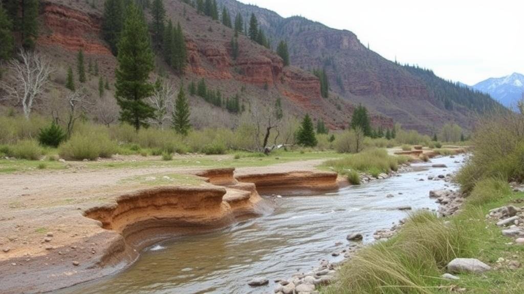
- Bank Undercutting: When water erodes the base of a streambank, the upper soil may collapse, exposing layers of sediments. heavier minerals, such as gold, tend to settle at the bottom, making undercut banks prime candidates for placer deposits.
- Layered Sediments: Pay attention to the stratification of sediments. Coarser materials tend to settle first, often indicating the potential presence of heavier placer minerals beneath finer soil.
Field Evaluation Techniques
Field evaluation of erosion patterns involves several techniques, including visual assessments and technological methods. Each technique offers unique insights into sediment distribution.
- Visual Inspection: Conducting a close-up examination of streambanks allows miners to note changes in vegetation, soil texture, and evidence of historical erosion, providing clues about sediment transport.
- GIS and Remote Sensing: Geographic Information Systems (GIS) can be employed to analyze large areas of land. Satellite imagery and topographic maps help visualize erosion and deposition patterns over time, guiding placer mining efforts.
Case Studies and Real-World Applications
Several successful placer mining operations have utilized erosion pattern analysis to enhance their findings. For example, in the Klondike region of Canada, gold prospectors studied the surrounding hills and the flow patterns of the Bonanza Creek. Their understanding of the erosional process allowed them to identify gravel deposits that carried high concentrations of gold.
Another example can be seen in the Yukon River, where miners systematically analyzed sediment stratification along the banks. As a result, they were able to predict the best locations for mining based on visible signs of mineral accumulation.
Actionable Takeaways
Predicting placer deposits through the analysis of erosion patterns requires careful observation and understanding of hydrological processes. Here are some actionable takeaways for miners:
- Conduct thorough visual inspections of streambanks while taking notes on sediment types and vegetation cover.
- Use GIS technology to access and analyze historical erosion data, allowing for better predictions of future placer areas.
- Always follow up visual assessments with core sampling to test for mineral presence before commencing larger mining operations.
Conclusion
By mastering the art of reading erosion patterns in streambanks, placer miners can significantly enhance their ability to locate valuable deposits. As erosion continues to shape our landscapes, the knowledge gained from these natural processes not only aids in mining endeavors but also contributes to a deeper understanding of our environmental interactions.


