How to Identify Likely Artifact Sites in Coastal Bluff Areas Prone to Erosion
How to Identify Likely Artifact Sites in Coastal Bluff Areas Prone to Erosion
Coastal bluff areas are dynamic landscapes where geological processes, human activity, and archaeological interests intersect. As these environments face increased erosion, the potential for uncovering significant artifacts rises. This article explores critical methods for identifying likely artifact sites in these vulnerable coastal settings, detailing strategies, methodologies, and real-world applications.
Understanding Coastal Bluffs and Erosion
Coastal bluffs are elevated landforms found along shorelines, typically composed of varying geological substrates such as clay, sand, or silt. Erosion in these areas is often exacerbated by climatic factors including rising sea levels, storms, and human activities like construction and land use changes. The resulting geological shifts can expose previously buried artifacts, making it essential for archaeologists and researchers to pinpoint high-potential areas for investigation.
Historical Context and Archaeological Significance
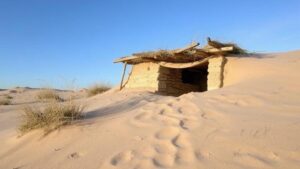
Artifacts found in coastal bluff areas often carry historical and cultural significance, providing insights into past human behaviors, migrations, and settlement patterns. For example, sites along Californias coastal bluffs have yielded tools and remnants of prehistoric human activity, illustrating how ancient communities adapted to changing environments. This context forms the foundation for systematic excavation and analysis, driving the need for refined identification methods.
Identifying Likely Artifact Sites
The identification of potential artifact sites within coastal bluff regions involves a multi-faceted approach incorporating geological analysis, environmental assessment, and archaeological reconnaissance. The following methods are key in this process:
- Geomorphic Mapping: Utilizing Geographic Information Systems (GIS) to map the physical landscape, researchers can identify erosion hotspots. GIS allows for the visualization of bluff erosion rates and areas where sediment displacement may expose artifacts.
- Soil Analysis: Examining soil profiles in bluff areas helps determine stratigraphy, sediment types, and historical layers. This information can indicate past human activity based on the distribution of artifacts within different layers.
- Remote Sensing: Airborne and terrestrial remote sensing technologies, such as LiDAR, can reveal surface anomalies and structures potentially indicative of human habitation.
Field Survey Techniques
Once high-potential areas are identified, field surveys employing systematic techniques become imperative. Effective methods include:
- Shovel Testing: Conducting shovel tests at regular intervals can yield artifacts from buried strata. This method is particularly effective in coastal bluffs where artifact layers may be dispersed due to erosion.
- Surface Collection: Gathering artifacts from bluff surfaces can provide immediate insight into past human activities. Researchers should stay vigilant during times of increased erosion, as storms and high tides can liberate artifacts from the bluff.
- Site Monitoring: Continuous monitoring of identified sites allows researchers to document changes over time, thereby informing strategies for preservation and excavation.
Case Studies and Practical Applications
Several case studies highlight the effectiveness of these methods. For example, along the Pacific Northwest coast, archaeologists utilized aerial surveys combined with local historical documentation to identify potential sites of indigenous habitation along eroding bluffs. The subsequent excavations led to the discovery of stone tools and evidence of subsistence strategies that enhanced our understanding of the areas historical occupation.
Also, in the Northeast, the implementation of geomorphic mapping techniques allowed researchers to accurately predict erosion patterns, resulting in the recovery of artifacts at sites previously deemed too risky for excavation due to stability concerns. Such efforts illustrate how integrated methodologies can yield significant archaeological findings in coastal environments.
Challenges and Considerations
While the methods outlined provide a robust framework for identifying artifact sites, challenges persist. Factors such as environmental regulations, funding limitations, and community engagement can impact fieldwork outcomes. Also, ethical considerations regarding the stewardship of cultural heritage necessitate that researchers proceed with caution and respect local sentiments surrounding excavation activities.
Actionable Takeaways
To wrap up, identifying likely artifact sites in coastal bluff areas prone to erosion requires an interdisciplinary approach that incorporates geomorphology, archaeology, and community engagement. key steps include:
- Employing technological tools such as GIS and LiDAR for mapping
- Conducting thorough soil analyses
- Utilizing varied field survey techniques for effective site assessment
- Documenting and monitoring sites regularly to adapt methodologies based on environmental changes
By adopting these strategies, archaeologists can maximize their chances of uncovering valuable historical artifacts while also addressing the pressing issues of erosion and conservation in these vulnerable landscapes.