Exploring Aerial Surveys from the 1940s to Spot Historic Sites Today
Exploring Aerial Surveys from the 1940s to Spot Historic Sites Today
Aerial surveys have transformed the way historians, archaeologists, and conservationists discover and document historic sites. Originating in the 1940s, the use of aerial photography has evolved significantly, incorporating advanced technologies and methodologies that provide a clearer and more comprehensive understanding of our cultural heritage. This article aims to explore the historical development of aerial surveys, their applications in identifying historic sites, and the technological advances that shape their use today.
The Emergence of Aerial Surveys in the 1940s
The advent of aerial surveys can be traced back to World War II when military reconnaissance necessitated the mapping of landscapes to strategize military operations. 1940s marked a crucial period; for instance, during the war, the United States Army Air Forces used aerial photography extensively to monitor enemy territories and gather intelligence.
Following the war, the practical applications of aerial surveys began to expand into civilian sectors, particularly in archaeology. Pioneering archaeologists like Geoffrey W. B. Adams and Kenneth P. L. Smith utilized aerial photography to reveal previously undocumented sites. A notable example is Adams’s work in the Great Plains region of the United States, where he succeeded in identifying prehistoric earthworks that were invisible from the ground.
Technological Advancements in Aerial Surveying
From the early 1950s onwards, significant technological innovations enhanced the functionality of aerial surveys. The introduction of infrared photography allowed archaeologists to detect subsurface remains and vegetation patterns that could signify archaeological sites.
- In 1958, the U.S. Geological Survey partnered with the National Park Service to conduct aerial surveys of ancient Native American sites.
- The development of digital imaging technologies in the 1990s revolutionized aerial photography, offering higher resolution images that improved site visibility.
Recent advancements, particularly the incorporation of drones and LiDAR (Light Detection and Ranging) technology, have further heightened the precision of aerial surveys. Drones outfitted with high-resolution cameras and LiDAR sensors enable the rapid acquisition of data over large areas, effectively uncovering features that traditional methods may miss.
Applications of Aerial Surveys in Historic Preservation
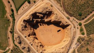
Aerial surveys serve a range of purposes in historic site identification and preservation. One of the most significant benefits is the ability to cover expansive areas quickly and efficiently, allowing for a broader understanding of historical geography.
For example, in 2015, researchers in Peru used aerial surveys to identify the ruins of a previously unknown ancient temple complex in the Sacred Valley. The project employed drone technology to capture 3D images of the site, which facilitated detailed analyses and public preservation efforts.
Similarly, at the ancient city of Teotihuacan in Mexico, aerial surveys have revealed residential complexes and pathways obscured by vegetation. Archaeologists now leverage these technologies to support excavation and conservation efforts, highlighting the importance of integrating modern technologies in historical research.
The Role of Aerial Surveys in Modern Archaeology
Aerial surveys possess the unique ability to enhance archaeological research while promoting engagement with cultural heritage. By showcasing the connectivity of historic sites through landscape perspectives, they foster understanding of ancient human behaviors and migrations.
- The ongoing Archaeological Survey of the IHR (Inland Heritage Region) in Southern England effectively demonstrates the synthesization of aerial surveys with ground-truthing–confirming discoveries through excavations.
- Also, collaborative projects with local communities have emerged, encouraging participatory heritage practices that increase public interest and investment in preserving historic sites.
Conclusion: Future of Aerial Surveys in Historic Site Identification
The integration of aerial surveys in historical site identification has changed the landscape of archaeological research since the 1940s. As technology continues to advance, the methodologies employed in aerial surveys are likely to become even more sophisticated, yielding richer data and insights into our past.
It is vital for historians, archaeologists, and conservationists to adapt to these technologies, as the future of heritage management depends on a collaborative approach that embraces innovation while respecting and preserving cultural histories.
As we look toward the future, fostering partnerships across disciplines and utilizing cutting-edge technology will be essential in uncovering the stories of our ancestors and ensuring that we preserve historic sites for generations to come.