Combining Geography and Logic to Decode Treasure Maps
Combining Geography and Logic to Decode Treasure Maps
Treasures–often depicted through the allure of maps filled with cryptic symbols and mysterious directions–have fascinated explorers and adventurers alike. Yet, beneath this romance lies a complex interplay of geography and logic that can unlock the secrets of these ancient documents. This article explores how the disciplines of geography and logic work together to decode treasure maps, offering a framework that combines historical context, spatial analysis, and critical thinking techniques.
The Historical Significance of Treasure Maps
Treasure maps have a storied history, dating as far back as the Age of Exploration. depiction of geographic features, such as mountains, rivers, and coastlines, played a pivotal role in navigation and claiming territory. Notable examples include the famous treasure map from Robert Louis Stevensons Treasure Island, which illustrated the fictional islands topography and key locations, such as Dead Mans Chest.
Understanding the historical context of treasure maps is crucial for decoding their content. Many maps were created during periods of colonial expansion, and as such, they often contain politically charged geography that reflects the intentions and aspirations of their creators. For example, maps from the Spanish conquest often highlighted areas rich in gold and silver, showcasing the geographic importance of wealth in shaping exploration routes.
The Role of Geography in Decoding Maps
Geography serves as the backbone of interpreting treasure maps. It involves understanding both physical geography (the natural landscape) and human geography (the impact of people on landscapes). When examining a treasure map, a geographer first analyzes:
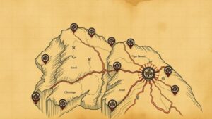
- Topographic Features: Hills, valleys, and bodies of water can act as landmarks or reference points. For example, a large mountain depicted on the map might indicate a certain height above sea level, which can guide the treasure seeker toward potential locations.
- Scale and Distance: Assessing the maps scale is essential for accurately determining real-world distances. A map drawn with a 1:1000 scale means that one unit on the map represents 1,000 units in reality, affecting how one might navigate the terrain.
- Coordinates and Compass Directions: Understanding latitude and longitude is vital for pinpointing locations on a map. A treasure map might include specific coordinates, and the use of a compass rose can indicate cardinal directions, further assisting in navigation.
Integrating Logic to Solve Geographic Puzzles
Logic complements geography by providing a systematic approach to extracting meaning from clues and symbols on treasure maps. Here are some logical frameworks that can be utilized:
- Deductive Reasoning: This involves starting with a general principle and applying it to specific cases. For example, if a map indicates that the treasure lies north of the old oak tree and you ascertain the location of the oak, you narrow down the possible area where treasure may be hidden.
- Inductive Reasoning: This method involves moving from specific observations to broader generalizations. If you discover similar landmarks on multiple maps, you can infer that these locations likely represent common points of interest across different treasure-hunting narratives.
Combining these reasoning strategies allows treasure hunters to form hypotheses about location based on geographic features and patterns observed on the map. By assessing various clues logically, individuals can weave together a cohesive understanding of where to search for treasure.
Case Studies: Successful Treasure Hunts
Real-world applications of combining geography and logic can be seen in several successful treasure hunts:
- The Oak Island Mystery: This legendary treasure hunt has captivated generations. Using sophisticated geographic mapping tools and various logical deduction methods, explorers sought to decipher clues related to the islands terrain, including water-filled pits and distinct land formations.
- The San Miguel de Archangel: In 1715, a Spanish galleon sank off the Florida coast, and its treasure remained lost for centuries. Modern treasure hunters employed both historical geography and deduction, utilizing satellite images and underwater mapping to locate the shipwreck and retrieve gold coins, thus validating the synergy between these disciplines.
Actionable Takeaways
For those aspiring to embark on their own treasure-hunting adventures, here are key takeaways:
- Study Historical Context: Understanding the era in which a map was created will provide insight into its symbols and landmarks.
- Use Geographic Tools: Employ technology like GIS (Geographic Information Systems) for accurate terrain analysis and mapping.
- Practice Logic Skills: Work on enhancing deductive and inductive reasoning to better interpret the clues found on maps.
To wrap up, decoding treasure maps requires a harmonious blend of geographic expertise and logical reasoning. By employing these tools, treasure hunters can navigate the complexities of these documents, ultimately transforming the art of searching for treasure into a systematic and more successful endeavor.


